The Algarve region in Portugal offers some beautiful walking and hiking trails that allow you to explore its natural beauty and diverse landscapes. These are just a few examples of the best hiking trails in the Algarve. Make sure to check the difficulty level and plan accordingly, wear appropriate footwear, and bring plenty of water and sunscreen when embarking on any hike.
Here are some of the best walking and hiking trails in the Algarve:

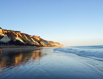
Rota Vicentina
This long-distance trail follows the rugged coastline of the Algarve and Alentejo regions. It offers stunning views of cliffs, sandy beaches, and pristine landscapes. The walking and hiking trail is divided into two main sections: the Historical Way, which takes you through rural areas and historical villages, and the Fisherman's Trail, which hugs the coastline.
Walking the Rota Vicentina in the Algarve is a popular choice for nature enthusiasts and hikers looking to explore the stunning coastal landscapes and rural areas of the region.
Here's a general guide on how to walk the Rota Vicentina in the Algarve:
- Choose your Route: The Rota Vicentina offers two main routes in the Algarve: the Historical Way (Caminho Histórico) and the Fishermen's Trail (Trilho dos Pescadores). The Historical Way follows inland paths and historical routes, while the Fishermen's Trail follows the coastline. You can choose to walk one or both routes, depending on your preferences and available time.
- Plan your Itinerary: Determine the number of days you have available for the walk and plan your daily distances accordingly. The Rota Vicentina website provides detailed maps and suggested itineraries for both routes, indicating distances, difficulty levels, and recommended accommodation options.
- Prepare your Gear: Make sure you have appropriate hiking gear, including comfortable walking shoes, a backpack, water bottles, rain gear, sunscreen, a hat, and other essentials. Consider packing light but carry enough supplies for each day's walk.
- Book Accommodation: Along the Rota Vicentina, there are various accommodation options, including guesthouses, hostels, and campsites. It's advisable to book your accommodation in advance, especially during peak seasons, to ensure availability.
- Follow Walking and Hiking Trail Markings: The Rota Vicentina is well-marked with signposts and trail markings. Look for the yellow and red markers for the Historical Way and the blue and green markers for the Fishermen's Trail. Pay attention to the signage and follow the designated paths to stay on track.
- Enjoy the Scenery: The Rota Vicentina offers breathtaking coastal views, pristine beaches, rugged cliffs, and peaceful rural landscapes. Take your time to appreciate the natural beauty along the way, and make sure to carry a camera or smartphone to capture the memorable moments.
- Be Prepared: Check the weather forecast before you start each day's walk and pack accordingly. Carry enough water and snacks, especially if you are walking in remote areas. It's also a good idea to have a physical map of the route as a backup in case of any technological or connectivity issues.
- Respect the Environment: The Rota Vicentina is a protected area, so it's important to respect the environment and leave no trace. Stay on designated paths, avoid littering, and follow any rules or regulations in place to ensure the preservation of the natural surroundings.
Remember to check the official Rota Vicentina website for up-to-date information, trail conditions, and any specific guidelines or recommendations. Additionally, consider consulting with local tourist offices or experienced hikers who have previously walked the route for additional tips and insights.

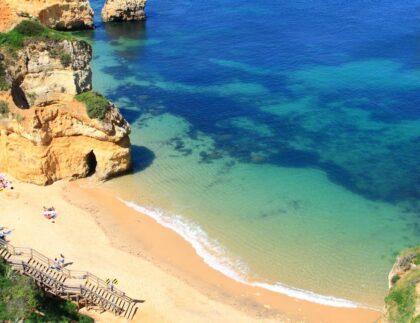
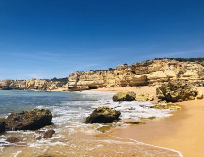
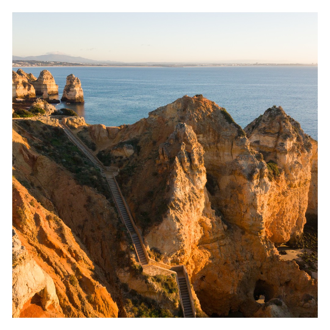
Seven Hanging Valleys Trail
Located in the Lagos area, this popular walking and hiking trail is known for its breathtaking coastal scenery. The trail follows the cliffs from Praia da Marinha to Praia da Vale Centeanes, offering stunning views of sea caves, rock formations, and secluded beaches. It's a moderately challenging hike with some steep sections.
The Seven Hanging Valleys Trail is located in the Algarve region of Portugal, specifically in the area of the stunning coastline near Carvoeiro.
Here's a guide on how to walk the Seven Hanging Valleys Trail in the Algarve:
- Starting Point: The trail usually starts at the Praia da Marinha, one of the most picturesque beaches in the Algarve. You can reach this starting point by car or public transportation, and there is parking available nearby.
- Trail Route: The Seven Hanging Valleys Trail is a linear trail that follows the coastline, offering breathtaking views of cliffs, hidden beaches, and sea caves. The trail covers a distance of approximately 5.7 kilometers (3.5 miles) one way, from Praia da Marinha to the Praia de Vale Centeanes.
- Trail Difficulty: The trail is considered moderate in terms of difficulty, with some steep sections and uneven terrain. It's important to wear appropriate footwear, bring enough water, and take precautions while walking along the cliffs.
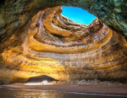
- Walking and Hiking Trail Highlights: Along the trail, you'll encounter various viewpoints that provide stunning vistas of the rugged coastline. You'll pass by several hidden beaches and coves, such as Albandeira Beach and Benagil Beach, where you can take a break and enjoy the scenery. The highlight of the trail is the famous Benagil Sea Cave, a must-see attraction in the Algarve.
- Return Options: The trail is a linear route, so you'll need to plan your return journey. You can either walk back the same way you came, or arrange alternative transportation such as a taxi or local bus service. Alternatively, you can combine the hike with a boat tour to explore more of the coastline and caves.
- Safety Precautions: Take precautions while walking along the cliffs, as some sections can be steep and slippery. Stay on designated paths and avoid getting too close to the cliff edges. Pay attention to tide times, as certain sections of the trail may become inaccessible at high tide. It's advisable to check the local weather forecast and be prepared with appropriate clothing and sunscreen.
- Enjoy the Experience: The Seven Hanging Valleys Trail offers breathtaking natural beauty and a chance to explore the stunning coastal landscapes of the Algarve. Take your time, enjoy the views, and appreciate the unique geological formations and marine ecosystems along the way.
Remember to bring essentials such as water, snacks, sunscreen, a hat, and comfortable footwear. It's also recommended to check trail conditions and any additional information from local tourist offices or hiking websites before embarking on the trail.

Foia Mountain
Foia is the highest peak in the Algarve, located in the Serra de Monchique mountain range. Hiking to the summit provides panoramic views of the region. There are several walking and hiking trails that lead to the top, including a 7-kilometer circular route starting from the town of Monchique.
To walk the Foia Mountain Trail in the Algarve, which is the highest point in the region, follow these general steps:
- Starting Point: The Foia Mountain Trail typically starts from the village of Monchique, located in the Serra de Monchique mountain range in the western Algarve. You can reach Monchique by car or public transportation.
- Trail Route: The Foia Mountain Trail is a well-marked hiking trail that leads to the summit of Foia Mountain. The trail is approximately 3.5 kilometers (2.2 miles) long and takes about 1-2 hours to complete, depending on your pace and fitness level.
- Walking and Hiking Trail Difficulty: The trail is considered moderate in terms of difficulty. It involves a gradual uphill climb, with some steeper sections towards the end. The terrain is rocky and can be uneven in places, so wearing sturdy footwear is recommended.
- Trail Highlights: As you ascend Foia Mountain, you'll pass through beautiful forests of cork oak and eucalyptus trees. Along the way, enjoy panoramic views of the surrounding countryside, including the Algarve coastline, lush valleys, and neighboring mountains. The summit offers a breathtaking view of the entire region.
- Safety Precautions: Although the trail is not overly challenging, it's important to take some precautions. Carry enough water, wear suitable clothing for the weather conditions, and protect yourself from the sun. Be cautious on uneven terrain and use caution when near cliff edges. It's also recommended to let someone know about your hiking plans and estimated return time.
- Nearby Facilities: Monchique village has various amenities such as cafes, restaurants, and souvenir shops. It's a good idea to stock up on supplies and use restroom facilities before starting the hike.
- Enjoy the Experience: The Foia Mountain Trail offers a rewarding hiking experience with stunning views of the Algarve's natural beauty. Take your time, appreciate the surroundings, and capture some memorable photos.
Remember to respect the natural environment by staying on the designated trail, not littering, and leaving no trace behind. It's also advisable to check the local weather forecast and trail conditions before starting your hike.

Paderne Castle Trail
This walking and hiking trail near the town of Paderne takes you to the ruins of Paderne Castle, an ancient Moorish fortress. The trail passes through picturesque countryside, including orange groves and cork oak forests. It's a relatively easy hike and offers a glimpse into the region's history.
To walk the Paderne Castle Trail in the Algarve, follow these general steps:
- Starting Point: The Paderne Castle Trail starts in the village of Paderne, located inland from the coastal town of Albufeira in the central Algarve. You can reach Paderne by car or public transportation.
- Trail Route: The Paderne Castle Trail is a circular route that takes you through the scenic countryside and leads to the medieval Paderne Castle. The trail is approximately 4 kilometers (2.5 miles) long and takes about 1-2 hours to complete, depending on your pace and the time you spend exploring the castle.
- Trail Difficulty: The trail is considered relatively easy, suitable for most fitness levels. The terrain is mostly flat, with some gentle slopes and dirt paths. It's recommended to wear comfortable walking shoes or sneakers.
- Walking and Hiking Trail Highlights: As you walk along the Paderne Castle Trail, you'll pass through charming rural landscapes, including olive groves, almond orchards, and vineyards. The highlight of the trail is the medieval Paderne Castle, which sits atop a hill and offers panoramic views of the surrounding countryside.
- Cultural Points of Interest: Along the trail, you may encounter other points of interest, such as the Paderne Church and the Roman Bridge. Take the time to explore these sites and learn about the local history and heritage.
- Safety Precautions: While the trail is relatively easy, it's still important to take some precautions. Carry enough water, wear appropriate clothing for the weather conditions, and protect yourself from the sun. Be mindful of uneven terrain and use caution when walking on dirt paths.
- Nearby Facilities: Paderne village has some amenities, including cafes and restaurants. However, it's a good idea to bring some snacks and water for the hike. Additionally, use restroom facilities before starting the trail.
- Enjoy the Experience: The Paderne Castle Trail offers a pleasant walking experience in a scenic and historical setting. Take your time, enjoy the peaceful countryside, and explore the castle at the end of the trail.
Remember to respect the environment and cultural heritage by staying on the designated trail, not littering, and being mindful of any specific guidelines or restrictions in place. It's also advisable to check the local weather forecast and trail conditions before embarking on your hike.

Rocha da Pena
Rocha da Pena is a natural park near Loulé known for its limestone cliffs and diverse flora and fauna. There are several trails within the park, ranging from easy strolls to more challenging hikes. The routes offer views of the surrounding countryside and the opportunity to spot wildlife.
To walk the Rocha da Pena trail in the Algarve, follow these general steps:
- Starting Point: The Rocha da Pena trail typically starts from the village of Pena, located near Loulé in the central Algarve. You can reach Pena by car or public transportation.
- Trail Route: The Rocha da Pena trail is a circular route that takes you through the stunning Rocha da Pena nature reserve. The trail is approximately 7 kilometers (4.3 miles) long and takes about 2-3 hours to complete, depending on your pace and the time you spend exploring.
- Trail Difficulty: The trail is considered moderate in terms of difficulty, with some steep sections and uneven terrain. It's recommended to wear comfortable walking shoes or hiking boots and bring trekking poles if desired.
- Walking and Hiking Trail Highlights: As you walk along the Rocha da Pena trail, you'll be surrounded by beautiful Mediterranean landscapes, including limestone cliffs, lush vegetation, and panoramic views. The highlight of the trail is the stunning rock formation of Rocha da Pena itself, which stands as a natural monument and offers a magnificent viewpoint.
- Natural Features and Wildlife: The nature reserve is home to a diverse range of flora and fauna, including unique plant species and birdlife. Keep an eye out for interesting rock formations, wildflowers, and any wildlife you may encounter along the way.
- Safety Precautions: Take precautions while walking on uneven terrain and use caution in steeper sections. Carry enough water, wear suitable clothing for the weather conditions, and protect yourself from the sun. Be mindful of any specific guidelines or restrictions in the nature reserve, such as restricted access to certain areas or the presence of wildlife.
- Nearby Facilities: Pena village has limited facilities, so it's recommended to bring water and snacks for the hike. Use restroom facilities before starting the trail.
- Enjoy the Experience: The Rocha da Pena trail offers a unique opportunity to explore the natural beauty of the Algarve's interior. Take your time, soak in the peaceful surroundings, and appreciate the scenic views along the way.
Remember to respect the environment by staying on the designated trail, not littering, and being mindful of any specific rules or regulations in the nature reserve. It's also advisable to check the local weather forecast and trail conditions before embarking on your hike.

Alvor Boardwalk
While not a traditional hiking trail, the Alvor Boardwalk is a pleasant walk that allows you to explore the estuary and marshlands of Alvor. The wooden boardwalk stretches for several kilometers and offers views of the lagoon, dunes, and birdlife. Mornings and evenings are the best time for walking on the boardwalks, especially during summer. There is no shade to hide hikers exposed to the sun during the entire walk. In the cooler winter months, you can do the walk any tie of the day.
To walk the Alvor Boardwalk in the Algarve, follow these general steps:
- Starting Point: The Alvor Boardwalk starts near the Alvor Beach in the town of Alvor, located in the western Algarve. You can reach Alvor by car or public transportation.
- Boardwalk Route: The Alvor Boardwalk is a wooden pathway that stretches along the estuary of the Alvor River. The boardwalk offers stunning views of the estuary, marshes, sand dunes, and the Atlantic Ocean. The total length of the boardwalk is approximately 6 kilometers (3.7 miles) round trip.
- Trail Difficulty: The boardwalk is relatively flat and easy to walk, suitable for all ages and fitness levels. It's wheelchair and stroller-friendly, making it accessible to everyone.
- Trail Highlights: As you walk along the Alvor Boardwalk, you'll have the opportunity to observe the diverse birdlife and unique ecosystems of the estuary. The boardwalk passes by salt pans, wooden fishing huts, and beautiful natural scenery. You can also take a detour to Alvor Beach to relax or explore the sand dunes.
- Points of Interest: Along the boardwalk, you'll find information panels and signs that provide insights into the local flora, fauna, and history. Take the time to read and learn about the natural environment and cultural heritage of the area.
- Facilities: Alvor has various amenities, including restaurants, cafes, and restrooms. You can find these facilities near the starting point of the boardwalk or in the town center.
- Enjoy the Experience: The Alvor Boardwalk offers a peaceful and scenic walking experience, allowing you to immerse yourself in the natural beauty of the Algarve's coastal ecosystem. Take your time, enjoy the views, and capture memorable photos.
Remember to respect the environment by following any guidelines or restrictions in place, such as not feeding wildlife or removing any natural objects. Additionally, be mindful of other walkers and cyclists who may be using the boardwalk.